You can change the projection type of the project. To change projection type:
• Click View/Edit Program Options.
•Select the Coordinate System tab.
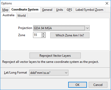
Australia/World Tabs: The Australia tab is a filtered list of commonly used coordinate systems used in Australia. The World tab provides a seemingly endless list of all coordinates systems.
Projection is a mathematical model of the Earth which approximates the shape of the Earth and enables calculations such as position and area to be carried out in a consistent and accurate manner.
Zone - Selected Projections can be broken up into zones. Australia ranges from zone 49 to 56. If you are unsure of what zone you are in, click  to be presented with an interactive map.
Reproject Vector Layers. If a vector layer (drawing) is detected as having a different projection to that of the project then the button will be enabled allowing you to change the projection of the drawing layers to match that of the project.
Lat/Long Format is the format in which the secondary coordinates will display in the bottom left corner of the main mapping window.