Spatial Data Library layers are served in WMS or WFS formats. When a layer is loaded, the layer name will be preceded with either  or
or  to denote the difference. This is important as to how these layers function.
WMS
Think of WMS layers as image layers despite the fact that they may look like a typical vector or drawing layer. As such there is limited functionality with WMS layers. Depending on the source of the layer you can view limited amounts of information about the objects displayed.
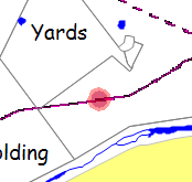
To navigate a WMS layer:
•Select the layer in the layer list.
•Click on an object on the layer. Object Data will display any information available. Note that you must make the layer the active layer first, it will not automatically change layers like it does when selecting objects on a drawing layer. Also, the object will not highlight, rather a red dot will display where the click is made. This is due to the fact that you are selecting pixels in an image and not an object.
•As this is an 'image' layer, object attributes (colours, labels, etc) cannot be edited. If editing and re-formatting is required then it would be advisable to use the WMS layer as a base to re-create the features on a new vector or drawing layer.
WFS
WFS layers provide more flexibility and behave more like a typical vector or drawing layer. One key benefits of a WFS layer is the ability to use the Copy and Paste function to copy the objects and their attributes to a local layer that is then available off-line.